Environmental projects
Putta Bucca Wetlands and River Rehabilitation
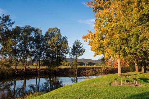
The Putta Bucca Wetlands have been transformed from an old quarry and dumping ground into a public reserve though the work of Council and volunteer groups since 2011. The site is now a facility for the community to enjoy as well as being environmentally sustainable, with more than 162 bird species recorded at the reserve, in addition to wallabies, platypus and turtles.
As part of these works entrance, car park and walkways have been constructed as well as bird hides, landscaping and signage, benching of the quarry on southern and northern sides, rehabilitation of the former sewerage treatment works and incorporation of the site into the wetlands reserve. Picnic and barbecue areas have been constructed as well as ongoing weed management and removal, revegetation and rubbish removal.
Council has been undertaking similar regeneration projects along the Cudgegong River and along Lawson Creek from Lawson Park to Putta Bucca. The regeneration of these urban waterways has involved mostly weed control and revegetation supported by the Central Tablelands Local Land Service, Environmental Trust, NSW Fisheries and Council.
Why remove the willows?
Willows are now regarded as one of Australia’s most serious riparian and wetland weeds and are listed as one of Australia’s 20 weeds of National Significance. Although willows were originally planted along the waterways to combat bank instability, such stability tended to be only temporary. Willows can grow continually in wet sediment and this along with fallen debris and matted roots that trap silt provides for the continual prolific spread of the species. This growth pattern causes blockages and changes not only to the flow of the stream but also to the course of a waterway with the associated erosion and flooding problems.
Willows guzzle water at a much greater rate than native species and have been known to completely dry out small creeks and swamps. It has been estimated that replacement with native species would potentially save three to four megalitres per hectare per year.
Willows drop massive amounts of leaves which when they break down results in an influx of nutrients that alters the temperature and oxygen content of the water. They also provide poor habitat and food source to native animals and the dense shade restrict other native plants from growing.
Roadside Corridor Management
The Mid-Western Regional Local Government Area (LGA) has more than 2445km of rural roads, including more than 1070km of sealed roads, 1375km of unsealed roads. That’s more than 6075 hectares of roadside reserve.
The roadside corridors are, in many areas, the only place where native vegetation remains uncleared. These corridors are vital for flora and fauna, as they provide habitats and corridors for movement across the landscape.
There are a number of issues for Council in the management of roadside corridors include loss of vegetation during road upgrade and construction works, noxious and environmental weeds, impacts from roadside mowing, slashing and spraying, impacts from utilities, hollow, bearing trees and potential risk to safety, unauthorised or illegal activities, bush fire hazard reduction works, drain and road verge maintenance procedures, materials stockpiling, drainage and water runoff and barriers to fish passage.
Council's Roadside Corridor Management project aims to manage these issues. The project:
- Assesses, ranks and maps roadside corridor conditions within the LGA
- Prioritises areas for actions and provides management guidelines aimed at improving habitat values and remnant vegetation conditions, particularly in identified high conservation value areas
- Identifies threatened species (or potential habitat) and communities and regionally significant species and communities
- Provides tools for assessment that are repeatable and provides qualitative and quantitative data for analysis, assessment and reporting
- Undertakes on ground rehabilitation works including weed and erosion control on area of high conservation value